 Photoblog with random writings...from NY's Lower Hudson Valley
In Praise of Maps
I used to love maps. Any maps. My father used to have a subscription to National Geographic when I lived at home. He still might. Perhaps a lifetime subscription. The day it arrived I knew my father would be head down into it for the night, there’d be no talking to him. I mean, no more than usual. It used to come in the brown paper wrapper back then. I’m not sure what covers it now, probably plastic…like the Hershey’s bars of today. I miss the foil, I must say. It was like a special present. Wrapped twice because it was just that good. It’s just as well, I suppose, they started using corn syrup instead of sugar and it hasn’t been the same since, and hey, let’s face it, I could use a little less of the stuff, double wrapped or not, but I digress.
What hasn’t changed about National Geographic is that they still include those wonderful free maps. Maps of wherever. Anyplace. Space. Africa. The United States. The whole world. I could always tell when that issue had a map. I’d peer down the top of the magazine and look for the perfectly folded map wedged inside the pages. But I’d have to wait until dad got home, showered, ate dinner, smoked and then found a spot on the couch and opened the magazine wrapper. Then I could get a look at the map.
I learned how to fold a map from National Geography. I had to, so it would fit back in the pages of the magazine. That was the deal. You can look at it, with clean hands, don’t wrinkle it, but it goes back here, just the way you found it. I’m still the queen of map folding. Just look in my glove compartment.
All those maps had to go back in the magazine, of course. There wasn't nearly enough wall space in our house for a whole world of maps. A few made it up on the walls in the basement, in the dining room before we got the hutch, and in dad’s room until mom got tired of looking at it. Some had push pins in all the places we’d visited. Needless to say, we didn't go broke on push pins. The world map had a worn spot where my mom’s hometown was in the Philippines. We must’ve pointed it out to everyone who ate dinner at our house. See here? tap, tap That’s where we’re from. Waaaaay over there on the other side of the world. Bet you’ve never been there. tap, tap
I’d always be doodling maps in my high school classes. Little tiny maps in the corners of my history notebook, or math, never physics or English because, well, I liked those classes. If it wasn’t a map, I’d doodle an arrow. Always an arrow. Can you analyze doodling?To this day, I doodle arrows when I’m on the phone. Like I need to go somewhere. Where am I going all the time? Where is that arrow pointing?
Maps are the first things I grab when I’m visiting a new city. When I went around Europe, I’d hop off the train, you know, back when I was younger, when I hopped, often. I'd hop, then stop in the tourist center, grab a map, orient myself then I’d be off to exchange some currency and enjoy the day, map in hand. My favorite thing, if I had time and the topography allowed, was to climb to the highest point in the city and compare what I saw to the map. As if I was expecting to find an errant road or some forgotten avenue.
I still collect my maps on vacation. We bring the luggage up to the hotel room and before the kids even have a chance to bounce on the beds and find the remote, I’m off to find a map (ok, and ice. I love free ice!). Even if I’ve been there before. What if there’s a new map? What if they added something? I’d hate to miss out! Even if you never use it while you’re out there, you have the picture of it in your head, just in case. Mission accomplished.
I still love maps. Old maps, new ones. I love them at the library in those big, giant map books. Or the ones that are so huge, they need a whole shelf to live in or even bigger, a mounted bracket on the wall! Who’s looking at all these maps? Where are they going? Why are they going there? So many questions. So many places!
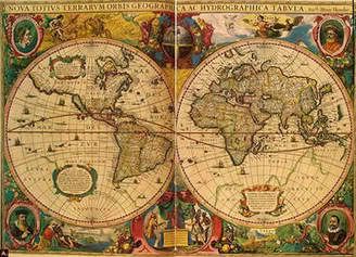
Now we have the internet, of course (and blogs…wondrous things, no?) and all of the maps floating around in cyberspace. Not quite the same as actually holding onto one, but what you lose in texture, you gain in sheer numbers and mind-blowing detail (see also: Google Earth). I’m amazed at how many there are out there! My favorite are those old world maps, usually brown in color, faded from time, I assume. They were bold visualizations of a world that few had seen, if any. They were vague and in most cases, as history proved, just completely wrong. If nothing else, though, they were thought-provoking art! A postcard looking down from space. This is where we live. This is pretty much how it looks. This is how you get here. Come visit. Leave the dogs home. See you soon.
Maps are good. It’s good to know where you are. Easier to get where you’re going if you know where you're starting out. And easier to get your friends to visit, no matter where in the universe they’re from.
posted by CarolynT @ 10:40 PM
2 comments
![]()
![]()


2 Comments:
National Geographics still come in the brown paper wrapper. I know because I wait each month for mine. I LOVE the maps.
Map reading is a real skill. My mother-in-law CANNOT read a map. She is totally useless at it. I guess MapQuest would work well for her. Those step-by-step directions so you don't have to actually interpret a map. I have no idea how she and my father-in-law travel to Florida in the car each year. He gets impatient, and she can't read the map.
How'd I miss this comment? November was a bit crazy, sorry!
I should get that subscription. I love the photos in there, too.
'Tis a skill...they're even teaching it to my son's class. How to orient yourself, follow a map, etc. On our last field trip, they gave them a map and set us out into the woods. Go! We had to follow. Luckily there was already a trail to follow. No lost kiddies...or chaperones. = )
Post a Comment
<< Home